Wednesday, December 28, 2011

Anchored in Barbados!

Position at anchor in Barbados: North 13*05'524 West 059*37'022

We made it! After 16 days and 2 hours from leaving the Cape Verdes we are now anchored off Bridgetown in Barbados. Just want to let everyone know we are okay, after loosing our SSB radio half way across and having no way to send out updates or get weather, we know a lot of you were worried for our safety. We still don't know what the problem is but will try to get it fixed here as soon as possible.

----------
radio email processed by SailMail
for information see: http://www.sailmail.com

Thursday, December 15, 2011

Cape Verde to Barbados - Day 5

Position at 20:49 UTC: North 14*27'731 West 034*36'033
1457 miles to go to Barbados.

We still have pretty much exactly the same conditions, the skies have been lovely and clear today and we've been making good speed between 6-7 knots. A lot of yachts ahead of us have been getting squalls and strong winds from an area of low pressure up ahead but it should have moved north before we reach it. We may get calmer conditions in a couple of days time and I have to admit we're looking forward to a little less rolling...can't complain about the speed we're making though!

----------
radio email processed by SailMail
for information see: http://www.sailmail.com

Wednesday, December 14, 2011

Cape Verde to Barbados - Day 4

Position at 19:08 UTC: North 14*36'316 West 031*59'699
1609 miles to Barbados.

Not much new to report today, The winds have dropped off to a steady 15 knots out of the east and we are making about 5.5 knots. A little bit sunnier today but otherwise everything is the same, we haven't touched the sails since we first set them so we're still being pushed down wind wing on wing with a 2 meter swell.

There seems to be an abundance of flying fish in the Atlantic and part of the day we spend scooping them off the deck to try and get them back to the sea before they die. Unfortunately they are not really big enough to eat and I have a feeling the Mahi and Tuna wont be so easy to catch!

----------
radio email processed by SailMail
for information see: http://www.sailmail.com

Tuesday, December 13, 2011

Cape Verde to Barbados - Day 3

position at 18:44 UTC: North 15*04'596 West 029*36'245
1748 miles to go to Barbados.

Today we have very much the same conditions as yesterday with 15-20 knots of wind out of the North East and seas around 2 meters, still lumpy and confused. The sky is very grey and overcast and the sea is covered in whitecaps, the temperature is a comfortable 21*C and at night we're still in need of thermals to keep the chill out.

We've spent the day cooking up food that we're worried will not stay fresh as we had to defrost the refrigerator this morning due to it over freezing and using up too much power. It's a shame to use up all our fresh meat at the beginning of the trip and I'm starting to wonder if it's just an excuse as Jimmy is desperate to start some serious fishing!!

----------
radio email processed by SailMail
for information see: http://www.sailmail.com

Monday, December 12, 2011

Cape Verdes to Barbados - Day 2

position at 19:15 GMT is: North 15*53'665 West 027*22'767
1878 miles to Barbados

We've had a good sail today averaging about 5 knots of boat speed, we have 15 knots of wind out of the ENE and very confused and choppy seas. It seems that there's swell coming from two or three different directions and so when they merge they push us around making for quite an uncomfortable ride. We're sailing downwind with the head sail poled out on one side and the full main on the other and luckily our wind steering unit is doing a great job of holding a course.

Our plan is to head a little south of our rhum line to Barbados so as to try and avoid some of the stronger winds that are generally found on a higher latitude. We heard on the net this morning that the yacht 'Egret' ahead of us reported loosing their rudder and so other yachts are changing course to help them. It sounds like they may me directly ahead of us by 5 days so we will see if we can help with fuel or anything else when we are closer.

Life on board is slowly falling into a more familiar rhythm of three hour watches at night and half day watches during the day. The lee cloth is rigged up on our sea berth and it's coming in handy to strap us into the bunk so we can get some relief from the constant rolling!

----------
radio email processed by SailMail
for information see: http://www.sailmail.com

Sunday, December 11, 2011

Cape Verdes to Barbados - Day 1

Position at 18:46 UTC: North 16*43'592 West 025*30'597
1987 Miles to Barbados

We spent a lovely few days relaxing in Mindelo on Sao Vincente island in the Cape Verdes. On friday we joined cruisers from five other yachts and caught the ferry over to Santo Antaou island for a day of exploring. We hired a driver with a mini van to take us around and were amazed at the stunning scenery. The islands remind us a lot of the Caribbean but much more mountainous and with a lot less tourists!

Mindelo also offered us the chance to fill up on Diesel(€0.84 per liter), Petrol (€1.60 per liter) and drinking water (€0.02 per liter). There are good laundry services that will wash for you or you can do it yourself. The marina is a little overpriced at €30 a night but we were more than happy to anchor out and there is a free dinghy dock. All in all we really enjoyed the stop and we're happy to be back in the more relaxed African islands.

Today it was time to leave so after doing some final provisions we upped anchor and left the anchorage at Midday. The wind was blowing up to 35 knots in the pass between the islands but now we seem to be in the wind shadow and are motoring with none, yachts ahead of us are reporting 20-25 knots and big seas so hopefully we'll pick that up before dark so we can set our sails in the light.

----------
radio email processed by SailMail
for information see: http://www.sailmail.com

Wednesday, December 7, 2011

Grande Harbour (Mindelo), Cape Verdes

Position at anchor: North 16*53'006 West 024*59'722

As the sun rose this morning the wind died off completely and we slowly motor sailed along the stunningly high coast of Sao Vincente Island in the Cape Verdes. By 10am we had pulled into the Port of Mindelo and dropped our anchor among the 40+ other yachts in beautifully calm water. Straight away we were visited by fellow cruisers to let us know where everything we could possibly need in town was including the fuel station, bank, bakery and laundry.

This afternoon we dropped the dinghy into the water and headed ashore to check in with immigration and the maritime police. With just a small fee of 5 Euros and very friendly officials we were cleared into the Cape Verdes within 15 minutes. Tomorrow we plan to explore the town but for now we're happy to relax on board and catch up with some much needed sleep!

----------
radio email processed by SailMail
for information see: http://www.sailmail.com

Tuesday, December 6, 2011

Las Palmas to Cape Verde - Day 7

Position at 19:08 UTC: North 17*48'045 West 024*31'716
61 miles to Mindelo, Cape Verdes.

The wind and seas have completely died down now so we're back to flying full sails with the main and headsail wing on wing for a comfortable down wind sail. We have about 10-15 knots out of the East with clear skies and are moving at an average of 4 knots, at this speed we should arrive in Mindelo on Sao Vincente island around 9am tomorrow morning.

We finally put the fishing lines out today and managed to hook two fish. The first was a little Mahi Mahi which we decided was too small so we put him back. The second was a larger Mahi Mahi perfect for a couple of meals. Jimmy has just fried up a couple of fillets with butter and teryaki within an hour of catching it and it smells delicious...can't get much fresher than that! So now we'll have dinner while watching our last sunset on this passage and look forward to discovering what the Cape Verdes hold in stall for us...fingers crossed a calm anchorage!!

----------
radio email processed by SailMail
for information see: http://www.sailmail.com

Monday, December 5, 2011

Las Palmas to Cape Verde - Day 6

Position at 19:26 UTC: North 19*20'095 West 023*42'962

We have 164 miles to go to Mindelo in the Cape Verdes and finally the wind has calmed down to a steady 15 knots out of the east. The seas are down to about 1.5 meters so we are finding the conditions much more comfortable and finally a couple of layers of clothing have peeled off. This afternoon a fog bank lowered around us so we only have visibility of just over a mile making everything pretty gray. At our boat speed of around 5 knots we should make landfall the day after tomorrow.

There's really not much else to report except that we ran the generator to make water today and it was finally calm enough to take a shower... so we finally have much sweeter smelling crew! We continue to check into the Magellan net on our SSB each morning and Captain Fatty Goodlander aboard Wildcard also runs a more informal net in the evenings at 6pm that we also check into. There's a bit of a fishing competition going on between the yachts and it seems the New Zealanders are well in the lead, we're still eating fresh food from the Canaries but tomorrow the lines will go out for the first time.

----------
radio email processed by SailMail
for information see: http://www.sailmail.com

Sunday, December 4, 2011

Las Palmas to Cape Verde - Day 5

Position at 19:28 UTC is: North 21*04'950 West 022*25'130
290 miles to Cape Verde

Finally the winds have begun to abate a little and we're no longer getting tossed around quite so much! With 20-25 knots out of the west and 3 meter seas our wind vane is finding it a lot easier to hold a course without our constant attention. We still have the third reef in the main sail and just a slither of headsail out on the pole to keep us balanced.

The sky has been over cast all day and we're hoping it's the tail end of the system passing over us. The forecast shows much more reduced wind and seas tomorrow so fingers crossed for a calmer day and the chance to take a much needed shower!!

----------
radio email processed by SailMail
for information see: http://www.sailmail.com

Saturday, December 3, 2011

Las Palmas to Cape Verde - Day 4

Position at 19:12 UTC: North 22*39'215 West 020*36'665

Well the wind we were expecting certainly filled in right on time today, with speeds of up to and gusting over 30 knots. The seas also increased to around 4 meters breaking and have made for a pretty rough day. Our wind vane really struggles to hold a course down wind when the waves are pushing us around so we have to sit and watch the helm ready to grab it if we start head side on to a wave. Hopefully things will start to calm down during the night and within a couple of days we should have calmer conditions. We're making good speed and still averaging between 6-7 knots with 426 miles to go to the Verdes.

Jimmy was visited by a pod of dolphins today who put on a show of acrobatics for him...it's nice to be reminded of what we enjoy about sailing especially on days when we're not really enjoying it at all!!

----------
radio email processed by SailMail
for information see: http://www.sailmail.com

Friday, December 2, 2011

Las Palmas to Cape Verde - Day 3

Position at 19:10 UTC: North 24*06'691 West 018*45'915

Another really fast day for us with boat speeds between 6-7 knots, the wind has increased to 25 knots and seas are between 2-3 meters. The sea around us is a mass of breaking waves pushing us around as Blue Moon surfs down the front of them. The wind has been slowly increasing and we're thankful that we're heading in the same direction and not trying to push against it.

With 558 miles to go to Mindelo we should arrive at this pace a day early, however, in 48 hours the wind is predicted to die down so we'll have to wait and see...not really trusting the forecast at this point. Trying to get sleep with the roll of the boat has been quite difficult, even with the help of the lee cloth strapping us in and several pillows wedging us in! Looks like we should have a clear night so lots of stars to help steer by.

----------
radio email processed by SailMail
for information see: http://www.sailmail.com

Thursday, December 1, 2011

Underway to the Cape Verdes-Day 2

Position at 19:17 UTC with 700 miles to go: North 25*52'320 and West 017*05'167.

Day two and we've been keeping a pretty good pace, the winds have increased to 20-25 knots and we're expecting them to build even more by tomorrow. We're sailing along at 6 knots with a double reefed main and a slip of a headsail, the seas are rough and around two meters high so we're getting knocked around a bit.

Our sea legs are slowly returning and we're generally getting back into the swing of three hour watches. We've passed a couple of container ships but otherwise sightings of other vessels has been pretty minimal, we have been warned to keep a look out for rowing boats as they head out to cross the Atlantic also...I definitely don't envy them!

----------
radio email processed by SailMail
for information see: http://www.sailmail.com

Wednesday, November 30, 2011

Underway to the Cape Verdes-Day 1

Position: North 27*37'222 West 015*36'583

We were finally able to get underway today at 11am after spending most of the morning wrestling the dinghy on deck, getting everything stowed away and scrubbing the very fuzzy anchor chain before bringing it onboard! We've just passed the southern point of Gran Canaria and are making a decent speed of 5.5 knots under a reefed mainsail and poled out headsail. The winds have been slowly increasing as the day goes on and a predicted 10 knots is now blowing a breezy 20.

Our course is set at 219* True and we're slowly relaxing back to life at sea...just enough time for a chicken curry dinner before the sun goes down!

----------
radio email processed by SailMail
for information see: http://www.sailmail.com

Tuesday, November 29, 2011

Las Palmas ~ Gran Canaria

Position at anchor: North 28*07'971 West 015*25'478

We've been anchored in Las Palmas for three weeks and have slowly been getting Blue Moon ready for her trip across the Atlantic. This has been our last stop to get any repairs done and to stock up with food at the big hypermarkets before heading to the Cape Verdes where we expect only the basic amenities.

Caroline has just returned back from a trip to England to visit family and friends while we're still so close and Jimmy's brother in law 'Todd' flew out for a week long visit from the states to keep him company. Every day cruising yachts have been leaving the port and heading out towards the Caribbean so we're starting to feel that it's time to go!

Our plan is to leave tomorrow morning and head 858 nautical miles south to Porto Grande (Mindelo) on the island of Sao Vicente in the north west Cape Verde islands. We'll stay there for up to a week to explore and do some hiking and then make the 2000 mile jump to Barbados in the Caribbean. I have to admit we're looking forward to getting closer to the equator and warmer weather as it has been getting pretty chilly here!

----------
radio email processed by SailMail
for information see: http://www.sailmail.com

Tuesday, November 1, 2011

Day 4 underway to the Canaries

Current Position @ 20:00 GMT: North 30*00'458 West 012*34'642

With just 68 miles to go until we make landfall in the Canaries we've had a great couple of days sailing. On day 2 we were able to fly the spinnaker with light winds out of the north west, by night fall they'd increased enough for us to pole out the headsail on the starboard side and let the main out on the port for a beautiful down wind run. We kept that set up until a couple of hours ago when the wind changed more out of the west so we flipped the headsail onto the port and are now making a comfortable 5 knots on course.

The weather has been great with clear skies during the day, just a little too cold at night for our liking so the thermals have come out and we're kitted out with about four layers during our watches. The wind vane has been steering an almost perfect course so no need for hand steering, we're enjoying watching the miles slip away as the big Atlantic swell carries us closer to warmer latitudes.

We've been in contact with other yachts around us all making about the same speed and each morning the Mag Net on the SSB keeps us updated to where everyone is. There will be over 20 yachts making landfall in the same anchorage as us so it should be interesting to see how we all fit in!

----------
radio email processed by SailMail
for information see: http://www.sailmail.com

Sunday, October 30, 2011

Underway from Morocco to the Canary Islands.

Current Position underway to the Canaries: North 32*51'680 West 009*15.140
Position while in Rabat, Morocco: North 34*01'652 West 006*49'378

After a great two week stay in Bouregreg Marina in Rabat, Morocco we are back underway and on Passage to the Canary Islands. Due to large swell outside the river entrance to the marina the port was closed for over a week so when the swell finally died down enough yesterday we all made a mad dash over the bar and back out to sea. We were joined by 21 other yachts so there's a convoy of us all heading in the same direction.

Last night we spent the whole time trying to avoid the Moroccan fishermen with their nets that line the coast with just little flashing lights to mark each end. Unfortunately the lights are all the same so it's impossible to tell where one net ends and another begins. We seem to be free of them now and are making good progress sailing down wind averaging around 5 knots of boat speed. With 310 Miles to go we should arrive at La Graciosa Island some time on Wednesday.

----------
radio email processed by SailMail
for information see: http://www.sailmail.com

Friday, October 14, 2011

Gibraltar to Rabat, Morocco.

Current position heading south along the Moroccan coast: North 35*18'011 006*17'440

After spending a week in Gibraltar preparing Blue Moon for our Atlantic crossing we're back underway. We have just passed through the straights of Gibraltar and into the North Atlantic Ocean. Thick fog engulfed us a we left the port this morning and we've been motoring through it most of the day. Crossing the shipping channel was pretty hair raising as we could only see a boat length in any direction...thank god for the AIS!

We are now motoring down the coast of Morocco and unfortunately the fog is back upon us and it's now dark outside. Instead of ships we have to worry about running into fishing nets and boats that don't show up so well on radar. So it's back outside for me as four eyes are better than two and I'll post more tomorrow when we arrive in Rabat.

----------
radio email processed by SailMail
for information see: http://www.sailmail.com

Wednesday, October 5, 2011

Ibiza to Gibraltar - Day 3

Current Position underway along the coast of Spain: North 36*23'433 West 003*46'432

We have 78 nautical miles to go to Gibraltar and still not enough wind to sail. This morning we were able to fly the headsail for a few hours but eventually it started to flog and had to pulled in. So now we're back to just motoring, the good thing is the auto pilot works perfectly in these conditions so we rarely have to touch the helm. The Shipping lanes are just south of us and now and again a cargo ship or ferry will brake off and pass in front of us heading to a Spanish port, other than that; a few fishing boats and lots of dolphins are the only signs of life we've seen.

Our arrival time in Gibraltar should be about midday tomorrow and our first stop will be the fuel dock to fill up on duty free Petrol and Diesel. We're looking forward to spending a few days in the luxury of a marina to mark the end of our time in the Med (and on British soil no less) and to supermarkets filled with English goodies!

----------
radio email processed by SailMail
for information see: http://www.sailmail.com

Tuesday, October 4, 2011

Ibiza to Gibraltar

Current Position Underway along the Spanish Coast: North 37*09'546 West 001*18'267

We left Formentera Island yesterday and are now underway along the Spanish Coast heading for Gibraltar. There's been very little wind so we're motor sailing along on an oily calm sea and making good progress. With a lot of shipping in this area it's been great to have the AIS system transmitting our position and it makes night passages much more enjoyable! With 212 miles to go we should be arriving in Gibraltar on Tuesday if the weather continues to hold in.

We've finally gotten in to some good fishing ground and today we caught four Mahi Mahi within a couple of hours of putting the lines out. We released two back and the other two have given us plenty of fillets for the next couple of days meals and without a freezer we're limited to how much we can keep.

----------
radio email processed by SailMail
for information see: http://www.sailmail.com

Monday, October 3, 2011

Ibiza and Formentera Island.

Position at anchor in Cala Saona, Formentera Island: North 38*26'151 East 001*23'216
Previous position at anchor off Las Salinas beach, Ibiza: North 38*50'435 East 001*23'382
Previous Position at anchor in Cala Boix, Ibiza: North 39*01'738 East 001*36'507

We're currently anchored off the west Coast of an Island called Formentera just south of the Island of Ibiza. The water is 10 feet deep and a beautiful turquoise colour, so crystal clear that we can see our anchor snuggly hooked up into the white sand ahead of us. We haven't seen an anchorage like this since the Maldives and it's hard to believe we're in the Mediterranean!

To be honest Ibiza was a very pleasant shock to me, I'd never been here before and it being pretty much the clubber's Mecca of the world didn't bring up images like the one I'm looking at! Gorgeous sandy beaches, great sailing and on the north side of Ibiza loads of beautiful little Cala's (bays) surrounded by towering rock formations...if only we had more time. It would be easy to spend a month or more here exploring the coasts but as usual we have a schedule and the Atlantic is calling!

----------
radio email processed by SailMail
for information see: http://www.sailmail.com

Saturday, September 17, 2011

Santa Ponca ~ Mallorca

Current position at anchor: North 39*30'905 East 002*28'281

After 250 nautical miles of Motor sailing it was a dream to finally drop the anchor and switch the engine off to some peace and quiet. At 5pm this evening our third day underway we pulled into the beautiful anchorage of Santa Ponca on the western coast of Mallorca. We found a spot between the medley of big and expensive motor yachts and let our senses adjust to the hive of activity going on around us as wake boarders and jet skis buzz by. The bay is overlooked by grand looking houses and hotels and it's obvious that we've just landed in the playground to the super rich...

----------
radio email processed by SailMail
for information see: http://www.sailmail.com

Friday, September 16, 2011

Day 2 ~ Underway Sardinia to Mallorca

Current Position: North 39*13'182 East 004*36'990

With very little wind blowing out of the East we're still motoring along hoping it will pick up just enough for us to cut the engine and sail. We have changed our plans a little as we're making better time than expected. We will now head for the west coast near the city of Palma to look for a good anchorage to use as a base to explore the island. With 105 miles to go we should arrive some time tomorrow afternoon.

The only good thing about motoring this long is that we've completely topped up the water tanks, the water maker has been pumping away doing a grand job of turning salt water into lovely fresh drinking water!

----------
radio email processed by SailMail
for information see: http://www.sailmail.com

Thursday, September 15, 2011

Underway from Sardinia to Mallorca

Current position heading west: N39*04.719, E007*08'.008

After a few days of exploring the South Western corner of Sardinia we are back underway again and heading to Mallorca in the Balearic Islands. We had just enough time to explore the lovely old town of Sant'antioco and stock up on provisions at the large Lidl Supermarket which seem to be popular here in Italy. Blue Moon wasn't neglected and Jimmy got to work doing an oil change on the engine and replacing oil and fuel filters while I fought the continuous battle of keeping salt and dirt off the decks.

The weather window has opened for a three day passage so we're making the most of the flat calm seas and motor sailing along. We should arrive Saturday morning in Porto Colom on the South eastern coast of Mallorca. The moon is still blessing us with it's presence so we have a beautiful bright clear night to look forward to...Just a shame we have to listen to the engine.

----------
radio email processed by SailMail
for information see: http://www.sailmail.com

Sunday, September 11, 2011

Porto Ponte Romano ~ Sardinia

Current Position at Anchor: North 39*02'29 East 08*28'04

The wind finally picked up enough last night for us to sail so we had speedy arrival in Sardinia this morning just as the sun was rising. Our first stop was the fuel dock in Porto Ponte Romano to top up on diesel (€1.55 litre) and the extremely friendly attendant was happy to work with us using mostly sign language to figure out how much fuel we needed - which depended on the amount of Euros in cash we had on board!

The wind was blowing hard out of the south so we had to cross to the west side of the bay to get protection from the building swell. We managed to find a spot of sand in all the sea grass, which seems to plague this side of the med, and anchored off a really beautiful long white sandy beach...we have it all to ourselves! Tomorrow if the winds change round to the North we'll head back over to the town to pick up some supplies and then start to explore some of the many anchorages in this area.

----------
radio email processed by SailMail
for information see: http://www.sailmail.com

Saturday, September 10, 2011

Underway to Sardinia

Current Position: North 38*35'085 East 009*47'100

At 6pm last night, with just a couple of hours of sunlight left, we dropped the mooring ball and started our passage to Sardinia. The winds were lightly blowing out of the north so we kept the engine running and haven't turned it off since. With flat calm seas and almost a full moon it was easy to spot and avoid the floats set by the local long line fisherman so no tangles with the propeller and a peaceful night at sea.

This morning I was awoken by the sound of a whirling fishing reel and the site of Jimmy struggling to pull in a beautiful Mahi Mahi or dolphin fish - Yippee...Our first fish caught in the med and tonight's supper! We're still motoring along as the sun sets on another day and looking forward to a calm and clear night. We should arrive at our anchorage on the South West Coast of Sardinia some time early tomorrow morning.

----------
radio email processed by SailMail
for information see: http://www.sailmail.com

Friday, September 9, 2011

Favignana Island ~ Sicily

Current Position On a mooring on south coast of Favignana Island: North 37*55'023 East 012*18'540

Our final stop in Sicily is the Small island of Favignana five miles off the north west tip. Favignana is one of three main islands that make up the Edagi Group and Marine Reserve. For the first time in Sicily we're not anchored off a commercial port which means the water is lovely and clean, perfect for swimming and snorkeling...it feels soo good to be back in the water again! We didn't even have to drop the anchor as we're snugly tied off to one of the free national park moorings.

The main town is just half a mile's walk across the island on the North side and a really popular spot for Italian tourists. A quaint little fishing harbour that was once home to one of Italy's largest Tuna factories. At night they open the old factory, which has been made into a museum, to the public and it's almost haunting to walk around a place that was once the site of so much Killing...the smell must have been unbelievable! These weren't just small tuna like the ones we're used to catching but often bigger and heavier than three men put together.

Over a hundred men would row out in wooden boats then set nets the size of football pitches, they'd wait for the tuna to swim in then slowly pull in the nets by hand. Once the tuna were cornered in a small area it would take five or six men to hook each fish with gaffs and pull them into the boats. Back at the factory they would cut them up, boil and salt the meat then pack it into tins that had also been made on site. A lengthy process that would involve the whole town including the women and children. However, like most industries new and faster ways of doing the job were created which meant the depletion of fish stocks due to over fishing and less work resulting in the factory finally closing down.

Yesterday we decided it was time to get some exercise and followed in the trend of the locals by renting bicycles for €4 each and rode around the whole island. Some of the roads are paved but many are just bumpy dirt and gravel tracks and our bums are definitely paying the price today. We've been here for five days waiting for a window to head north to Sardinia and it looks like we may have our shot this weekend with a window of two days of southerly wind. If the northerly winds slow down enough we may leave tonight and head for the South West coast (200 miles)taking two nights but if not we'll wait until the morning and head instead for the South East corner (150 miles) arriving the following day...watch this space for an update!

----------
radio email processed by SailMail
for information see: http://www.sailmail.com

Sicily ~ South Coast Anchorages.

30/08/11 - Pozzallo: North 36*43'182 East 014*50'375
Anchored behind the harbour break wall off the town. The Coast Guard moved us from our first anchor spot as we were within the 300 meter no anchor zone, very friendly no probelms. Small town with Conrad supermarket and bakery for supplies, fuel at dock in marina.

31/08/11 - Marina Di Palma: North 37*10'025 East 013*43'421
Our first choice of an anchorage at Licata wasn't possible as a large marina has been built in it's place! Wanting to avoid paying summer rates in the marina so we moved on down the coast to the small fishing town of Marina Di Palma and anchored 300 meters off the small harbour. An open road stead anchorage so not much protection but it was calm the night we stayed there, we didn't go ashore and left early the following morning.

01/09/11 - Porto Empedocle: North 37*17'036 East 013*31'543
Yachts can anchor on the western side of the inner breakwall, no room to tie up in the harbour as far as we could see. The anchorage was very comfortable, the town is small but interesting to explore and has good provisions at Carrefour mini market. From here we caught the bus to the Valley of the Temples near the city of Agrigento, well worth a visit. The bus leaves regularly from the east side of the port and takes roughly 20 minutes to get to the temples.

04/09/11 - Mazara Del Vallo: North 37*38'744 East 012*35'330
Again just another over night stop off what looks to be quite a big city. We anchored off the Eastern side of the inner break wall gaining what little protection we could from the larger outer western break wall. The swell from the south east made for a rolly night and the bottom is thick with sea grass so not the best anchorage but fine for an overnight stop. There is a marina which would be advisable if wanting to spend more time and fuel is available from the dock.

----------
radio email processed by SailMail
for information see: http://www.sailmail.com

Monday, August 29, 2011

Porto Palo, Sicily.

Current position at anchor in Porto Palo (South east point of Sicily): North 36*40'105 East 015*06'790

It was a hard decision but today we left Siracusa and one of our favourite anchorages in the Med. We were up early enough to head into town to the market to do a final stock up on yummy cheese and fresh fruit and vegetables. It's amazing how lively the city is at 8am with the cafes full of Sicilians drinking coffee and meeting up with friends before work. Our favourite cheese guy was as lively as ever and we were even treated to a free Sicilian sandwich and glass of red wine...Yes for breakfast - Sicilian hospitality will be hard to beat!

After a quick drive through the anchorage to say goodbye to our friends on other boats, we picked up anchor and sailed out of the Port around midday. It was a 25 mile motor sail down the South East coast to Port Palo on the Southern point, a big harbour with two giant break walls protecting us from any Swell from the South. We dropped anchor in 10 feet of water in lovely sticky mud and are snuggly settled in for what we hope to be a peaceful night.

----------
radio email processed by SailMail
for information see: http://www.sailmail.com

Sunday, August 28, 2011

Siracusa, Sicily.

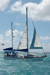
Current Position at anchor in Grand harbour, Siracusa: North 37*03'504 East 015*17'026

After arriving in the port of Siracusa a week ago we've been completely immersed in the Italian culture. The city was built on an ancient Greek settlement founded in 737 BC by the Corinthians. Home to such sites as the ruins of the Greek Temple of Apollo, extensive Paleo-Christian catacombs and The Fountain of Artemis in Piazza Archimede, it's an amazing city to stroll around and explore.

The colourful morning market has provided us with a tasty array of Sicilian treats including roasted mozzarella, Green & black olives, Tortellini Pasta, Salami and Italian Sausage. We've gotten our fix of Pizza and seafood pasta in a great local restaurant and the coffee shops for great frappes and deliciously fresh Cannoli!

We finally bit the bullet and invested in a wireless dongle so we can pick up internet on the boat, using a local phone network provider called 'wind' we now have unlimited connection for just €15 a month. Our knowledge of the Italian language is pretty much non existent but with our broken Spanish, the locals limited English and a lot of sign language we seem to be coping surprisingly well.

This has been one of our favourite stops in the Mediterranean so far with the combination of a great anchorage, a city full of beautiful buildings, amazing food and extremely friendly people we're going to find it really hard to leave.

----------
radio email processed by SailMail
for information see: http://www.sailmail.com

Saturday, August 20, 2011

Underway to Sicily.

Current Position underway in the South Ionian Sea: North 36*57'854 East 019*03'775

After a few relaxing days exploring Methoni and the ruins of the Venetian fort and Turkish castle we are now underway to Sicily. Yesterday we caught the bus to the town of Pilos 20 miles north along the coast from Methoni. We checked out of the country with the Port Police and picked up a few supplies including some local wine, olive oil and fresh veggies. At 7pm last night after a hectic few hours stowing everything away, mounting the wind steering vane and putting the dinghy on deck, we upped anchor and left Greece. It's sad to leave as we've really loved everything about Greece; the people are really friendly, the scenery is beautiful and the food is delicious...we look forward to coming back and exploring again some day!

As for now though we're 120 miles from Methoni on a west bound course towards the town of Siracusa on the east coast of Sicily. We have 178 miles to go and we're sailing along with 15 knots of wind out of the North West, the seas as usual for the med are uncomfortably bumpy but we're making good time at a speed of 5 knots. At this pace we should arrive in Siracusa on Monday morning. The wind vane is steering for us so we've just sat down to watch the sun set while enjoying a hot bowl of Chilli con Carne, the weather forecast is for much the same winds so fingers crossed we should have a very pleasant night!

----------
radio email processed by SailMail
for information see: http://www.sailmail.com

Monday, August 15, 2011

Methoni - Peloponnesse, Greece.

Current position at anchor in Methoni harbour: North 36*48'921 East 021*42.587

After a rough sail from Patmos to Naxos Island we were lucky to get a great sail the next day, 55 miles to the town of Adhamas on Milos Island. Milos, the origin of the famous Venus de Milo statue, was as far west as we made it last year before heading back to Turkey so it was a great feeling to be back knowing from here on everything would be new. We spent a couple of days sitting out another 30 knot Meltemi filling the time stocking up on fresh food in the small supermarket, getting Jerry cans of fuel from the petrol station across from the beach and jerry cans of water from the public dock down town. We also squeezed in a bus trip up to the town of Plaka high up the mountain offering breathtaking views of the island.

We caught up with friends Carolyn and Cap'n Fatty Goodlander from the yacht 'Wild Card' who we hadn't seen since last year and who are also planning to cross the Atlantic this year. By coincidence they were in need of a new head sail after blowing theirs out in a strong Meltemi and it just so happened we had picked one up from another cruiser in Turkey. It turned out to be a little too big for our boat but after a quick measurement discovered it would fit Wild Card perfectly and thus the sail has found a new home!

Three days after we arrived the wind calmed down and at 6pm on the evening of the 13th we said our goodbye's and sailed out of the harbour. We had just under 100 nautical miles to our next anchorage of Port Kayio on the southern coast of the Peloponnese. We spent the night sailing with light winds out of the North West and then motoring when they eventually died off. Our first night sail in just under a year and we were blessed with calm seas, clear skies and a beautiful full moon...not a bad way to be eased back in! At 5pm yesterday evening we dropped anchor in Port Kayio encompassed by a stunning mountain range which has created a perfect natural harbour.

After an extremely peaceful night catching up on sleep this morning we upped anchor just as the sun began to rise and motor sailed the 50 miles north west to the town of Methoni. We've just set our anchor amid a small group of international cruising yachts and are comfortably nestled behind the protection of the large Venetian fort that stands out from the headland. The water is crystal clear, 15 feet deep and the bottom is great holding in sand. Our plan is to spend a few days exploring the town and fort while keeping an eye on the weather and looking for a good window to sail the 300 miles west to Sicily.

----------
radio email processed by SailMail
for information see: http://www.sailmail.com

Tuesday, August 9, 2011

Naxos Island

Current Position at anchor on South Coast of Naxos Island: North 36*56'100 East 025*28'301

We were finally able to leave Patmos Island today, with a weather forecast of 15 knots of wind from the North West it sounded a lot more appealing than the 30 knots we've had for the past week. We tried to leave a couple of days ago and after an hour of bashing into huge waves we had to turn around and head back for cover. Today started off well but the winds slowly increased and half way thorough the day we were faced with the same high winds and big waves, by the time the weather had filled in we'd gone too far to turn back so had no choice but to carry on.
We covered over 55 nautical miles in 11 hours with a double reef in the main and a slither of head sail, the boat is caked in salt and pretty much everything down below that wasn't tied down was flung around the cabin...we really can't figure out the Greek weather.
We're now very happily anchored in a beautiful calm bay that we've affectionately named 'sheep anchorage' (due to the huge herds of sheep that cover the hills) and are looking forward to a shower, a hot meal and a good nights sleep. Supposedly tomorrow the weather will be 'even better' so we plan to head on to Milos Island and another 55 mile sail west of here...we shall see if the forecast can ever be trusted!

----------
radio email processed by SailMail
for information see: http://www.sailmail.com

Sunday, July 31, 2011

Goodbye Turkey...Hello Greece!

Current Position at anchor in the South bay of Lipsos Island, Greece: North 37*16'770 East 026*46'153

We checked out of Turkey on Friday in Bodrum, after much hassle avoiding a 75 Euro agent fee, which we managed to do but as usual something that should have taken half an hour took half a day instead. The blow was softened a bit by us discovering a duty free shop at the ferry terminal where we had to get our passports stamped and thus we smuggled out a couple of bottles of cheap liquor in our backpacks...typical cruiser style!

This morning we upped anchor and after topping up with fuel and water at the marina we motored the 25 miles to Lipsos Island in the Northern Dodecanese of the Greek islands. With a 15 knot head wind it was slow going but at least the engine got a good run and we topped up the power in the batteries and have enough hot water to last us a few days.

Tomorrow we'll head 10 miles to the west to the town of Skala on Patmos island, follow in our footsteps of last year and fingers crossed complete a smooth check in to Greece.

----------
radio email processed by SailMail
for information see: http://www.sailmail.com

Thursday, July 21, 2011

Marmaris to Bozuk Buku

Current Position at anchor in Bozuk Buku: North 36*34'490 East 028*00'660 - Good holding in 25ft of sand and weed.

After a month of endless hard work both on the hard in Yacht Marina and at anchor in Marmaris bay we have finally 'almost' completed all the jobs to get Blue Moon back into a fully functional live aboard cruising boat. Today that hard work paid off as we blew out the cobwebs and made our first step back into our Mediterranean cruising season.

This morning we picked up anchor and motored (against the wind of course) 27 nautical miles west along the coast and back to the beautiful anchorage of Bozuk Buku. Also known as Port apolotheka or ancient Loryma, the bay is overlooked by the ruins of an ancient citadel and dotted with small fish restaurants nestled in the valleys of the imposing rocky hills.

We're heading up the coast tomorrow towards Bodrum where we'll do a final stock up with food and fuel and then check out of Turkey.
For now it's off to enjoy a cocktail while watching another great sunset!

----------
radio email processed by SailMail
for information see: http://www.sailmail.com